Tree Risk Assessment in Shenandoah
Tree Risk Assessment for Shenandoah homes - local conditions, a clear process, and one call to get it started.
Tree risk assessment in Shenandoah is a neighborhood trade: same sky as everywhere in the metro, different trees, different soils, different targets.
The assessment exists because the alternatives are bad. Guessing produces either complacency (the tree was 'fine for years' until the night it was not) or panic (sound century oaks removed on a fear that a reading would have retired). Between them stands the evidence: defect by defect, target by target, likelihood by likelihood - and a plan that spends money only where the arithmetic says to.
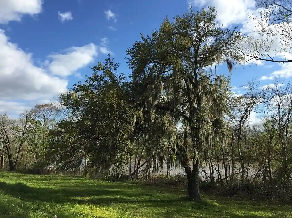
Shenandoah is the far-east anchor of the city's subdivisions - a large, established community of curving streets and wooded lots along Jones Creek, close against the Amite River bottoms that flooded so hard in 2016.
Local conditions shape the work here. 1970s-1990s traditional homes on wooded lots, many near Jones Creek and its tributaries - and that shapes the tree work directly. Creek-bottom canopy is wet-ground canopy: trees rooted in soil that saturates for weeks, bottomland species mixed with subdivision plantings, and 2016 flood stress still working its way out of trunks a decade later. For tree risk assessment in Shenandoah, likelihood and consequence scored separately here turn anxiety into a schedule.
What the tree risk assessment map of Shenandoah looks like, drawn honestly, is a set of small clusters: the streets near the Shenandoah Estates entrance and Jones Creek Road with their shared canopy, the older blocks with their shared aging species, the newer plantings with their shared shortcuts. Every visit adds a tree to the map, and the map is what makes the next visit faster, sharper and cheaper to scope.
Signs Shenandoah Homes Need Tree Risk Assessment
You are buying or selling a home with mature trees
The canopy is part of the property's real condition - a pre-sale assessment prices the risk honestly for both sides instead of leaving it as a surprise.
An insurer, HOA or court needs a written opinion
Coverage disputes, neighbor-tree questions and post-storm claims all run on documents.
A storm changed a tree and you cannot unsee it
New lean, lifted soil, a split you found in the cleanup - post-storm assessment converts worry into a keep, mitigate or remove decision with reasons.
Why This Work Runs in Shenandoah
Baton Rouge's risk landscape is dominated by three facts: a heritage canopy of great age, a storm season that tests it every year, and clay-and-loess soils that saturate, shift and shrink across the calendar. Risk here is therefore not static - the same tree's likelihood genuinely changes between the dry autumn and the soaked September, and a local assessment says which season's tree it is judging.
Creek-bottom canopy is wet-ground canopy: trees rooted in soil that saturates for weeks, bottomland species mixed with subdivision plantings, and 2016 flood stress still working its way out of trunks a decade later. Shenandoah readings pay special attention to root plates and lean - the failures here start at the ground, in the wet, before they show in the crown.
In Shenandoah, that plays out street by street - and the rating lands in a dated written report the property file can keep. The pattern in Shenandoah rewards the homes that read their trees in the off-season; the rest meet the same problem at its seasonal peak.
Fall's quieter risk is the backlog. Every weakness the storm season exposed - a union that opened, a crown that lost its balance, a root plate that shifted in wet ground - sits through the pecan drop and gets heavier. The fall habit that pays is the short list done early: damage finished properly, structure restored, and the questionable trees read before the winter rains saturate the ground again.
On the day, expect the visit to start with questions and a walk-around, not a saw. The professional confirms the problem, shows you the evidence - the cracked union, the lifting root plate, the conk at the base - and explains the plan before any work begins, and you get the findings in writing when it is done.
This season, the watch item in Shenandoah is the sky: every summer cell that builds over the Capital Region tests the trees below it, and the homes near the Shenandoah Estates entrance and Jones Creek Road read the results first.
Before you call, a five-minute walk pays for itself: note where you have seen limbs drop or crowns thin, check the ground at the base for heaved soil or mushrooms, and look at the tree's outline from the street for anything newly lopsided. That list, given on the call, gets the right equipment on the truck.

How Tree Risk Assessment Works in Shenandoah
The full step-by-step process for this service - the reading, the scope, the work itself and follow-up - is laid out on the main Tree Risk Assessment page. In Shenandoah the same sequence runs with the local map in hand: the canopy and ground around the Shenandoah Estates entrance and Jones Creek Road, the housing pattern described above, and the storm exposure this neighborhood actually carries.
The Shenandoah Angle
Ask anyone who services trees in Shenandoah and they will tell you the pattern repeats: the storm load, the saturated ground, and the seasons grade the result. Where the failures land hardest follows the housing. 1970s-1990s traditional homes on wooded lots, many near Jones Creek and its tributaries.
And the trees overhead carry their own local accent. Creek-bottom canopy is wet-ground canopy: trees rooted in soil that saturates for weeks, bottomland species mixed with subdivision plantings, and 2016 flood stress still working its way out of trunks a decade later. Shenandoah readings pay special attention to root plates and lean - the failures here start at the ground, in the wet, before they show in the crown. That is why tree risk assessment in Shenandoah is planned from a tree reading rather than from a script - the visit reads this map before any scope is chosen.
Shenandoah does not sit alone on the map. It weathers the same storms as Bluebonnet, Sherwood Forest and Old Jefferson - the same cells cross the metro, the same trees age into the same systems, and the same seasons move through all of them within the same few weeks. The neighborhoods lean on each other here: the same storm cell grades them all within the same hour.
On the route map, Shenandoah sits in the baton rouge subdivision group, ZIP 70817 - close enough to Bluebonnet, Sherwood Forest that crews work them on the same runs. The route view is also the honest one: it is how the weather actually moves through Shenandoah across a season.
Prices in this trade are quoted from scopes, and scopes in Shenandoah are quoted from trees - which is why the tree risk assessment conversation that starts with a visit produces a number, and the one that starts with a number produces a conversation. The visit is not a hurdle before the price; it is where the price comes from.
Prevention That Helps in Shenandoah
- Tell the assessor your plans for the property; consequence changes with your intentions.
- Act on the report's intervals - a monitoring recommendation is a date, not a dismissal.
- Do not let a single dramatic defect hide the quieter ones - the assessment reads the whole list.
1970s-1990s traditional homes on wooded lots, many near Jones Creek and its tributaries.
Keep Exploring
Tree Risk Assessment nearby:
- Tree Risk Assessment in Bluebonnet
- Tree Risk Assessment in Sherwood Forest
- Tree Risk Assessment in Old Jefferson
- Tree Risk Assessment in Denham Springs
More services in Shenandoah:
- Emergency Tree Service in Shenandoah
- Lot & Land Clearing in Shenandoah
- Tree Services in Shenandoah
- Arborist Services & Tree Care in Shenandoah
See the full tree services page for Shenandoah and the Tree Risk Assessment overview for Baton Rouge.
Tree Risk Assessment in Shenandoah - Questions
What exactly does a tree risk assessment in Shenandoah produce?
A written, dated report: each assessed tree's species, condition and defects; its likelihood of failure within a stated window; the targets in its fall zone; a risk rating; and a mitigation recommendation with timing. It is part diagnosis, part plan, part legal record - and it is what insurers and courts mean when they ask whether the tree was 'known to be dangerous.'
Does a high risk rating mean the tree must come down in Shenandoah?
No - it means the risk must come down, and removal is only one route. Pruning reduces sail and removes the defective part; cabling supports a weak union; moving the target (the playset, the parking) cuts consequence to near zero. Removal is the recommendation when the defect is in the trunk or roots and no mitigation reaches the rating the tree's targets demand.
Does Tree Risk Assessment in Shenandoah cover the streets near the Shenandoah Estates entrance and Jones Creek Road?
Yes - the blocks around the Shenandoah Estates entrance and Jones Creek Road are part of this page's map, along with the rest of Shenandoah. The landmark is named here because it anchors the neighborhood's pattern: the canopy and ground around it shape where the work concentrates.
A Tree Down, Leaning, or Dropping Limbs Over the Roof?
One call connects you with a tree professional serving Baton Rouge and the surrounding Capital Region communities - removal, trimming, stump grinding, storm cleanup and arborist care.
📞 Call Now